NASA Earth Observatory Tracks Autumn Valley Fog Across Appalachia
Satellite observations reveal how seasonal radiation cooling traps low-lying cloud formations across the Appalachian Plateau and Cumberland River valleys.
EXECUTIVE BRIEF // KEY TAKEAWAYS
Satellite observations reveal how seasonal radiation cooling traps low-lying cloud formations across the Appalachian Plateau and Cumberland River valleys.
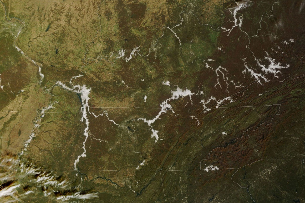
Satellite observations released by NASA News Releases through the NASA Earth Observatory highlight a recurring seasonal meteorological phenomenon across the eastern United States, where autumn mornings generate dense valley fog that traces the branching topography of the Appalachian Plateau and the Cumberland River before burning off by afternoon. Captured from orbit, these high-resolution visual records demonstrate how complex terrain directly governs localized atmospheric dynamics during the transition from late summer to winter.
Understanding the formation and dissipation cycles of radiation fog in river basins and dissected plateaus carries significant operational value for regional aviation, inland waterway navigation, agricultural management, and microclimate modeling. As satellite remote sensing instruments provide increasingly granular monitoring of boundary-layer meteorology, transportation networks and environmental researchers rely on orbital observations to anticipate visibility hazards and track surface-atmosphere energy exchanges across rugged terrain.
Topographical Mechanics and Seasonal Radiative Cooling
According to the NASA Earth Observatory report, the visual pattern observed from space resembles a dendritic network of white channels cutting through the darkened ridges of the Appalachian Plateau. During clear, calm autumn nights, the Earth's surface loses heat rapidly through longwave infrared radiation. Because longer nights allow for extended cooling periods compared to summer, air immediately above the ground chills substantially.
In regions characterized by steep relief—such as the deeply incised gorges and branching valleys surrounding the Cumberland River—cold, dense air drains downslope from the higher ridges and pools at the valley floors. When this sinking air cools to its dew point and interacts with moisture evaporating from the relatively warm river surface, water vapor condenses into suspended droplets, forming dense radiation and steam fog confined strictly within the topographical contours.
Low clouds trace the branching valleys of the Appalachian Plateau and the Cumberland River, then burn off by afternoon.
From orbital altitudes, the sharp boundary between the fog-filled valleys and the cloud-free ridgetops creates a high-contrast map of the underlying watershed. Every tributary, hollow, and bend of the Cumberland River basin becomes distinctly outlined by the trapped stratus and fog layers until solar heating intervenes later in the day.
Diurnal Dissipation and Operational Implications
The lifecycle of Appalachian valley fog is tightly bound to the diurnal solar cycle. As noted in the NASA Earth Observatory release, the low cloud formations persist through the morning hours but systematically burn off by the afternoon. Once sunlight penetrates the upper atmosphere and warms the surrounding valley walls and the top of the fog deck, convective mixing resumes. Rising temperatures lower the relative humidity of the trapped air mass, causing the suspended water droplets to evaporate back into invisible water vapor.
For regional infrastructure and economic operations across the Appalachian corridor, this daily cycle presents measurable logistical challenges. Highway transit corridors that follow river valleys and mountain gaps experience sudden, localized drops in visibility during peak morning transport hours, while higher-elevation roadways remain completely clear. Similarly, commercial barge traffic and recreational navigation along the Cumberland River system must account for restricted morning sightlines that resolve only after solar insolation destabilizes the temperature inversion.
Beyond transportation safety, persistent morning fog influences local ecological and agricultural systems within the plateau. By shielding valley floors from direct early-morning solar radiation, the cloud cover moderates diurnal temperature swings, reduces evapotranspiration stress on riparian vegetation, and provides vital moisture inputs to temperate forest ecosystems during drier autumn months.
Advancing Boundary-Layer Observation from Orbit
The ability of NASA Earth Observatory sensors to resolve fine-scale valley fog illustrates the broader utility of spaceborne Earth science platforms in monitoring boundary-layer meteorology. While ground-based weather stations often miss localized fog events confined to narrow river gorges, moderate- and high-resolution satellite imagers capture the spatial extent and dissipation timing across entire drainage basins simultaneously.
Looking ahead, continuous orbital monitoring of seasonal cloud and fog patterns across the Appalachian Plateau and Cumberland River watershed will continue to refine numerical weather prediction models. By integrating topographical drainage data with real-time satellite imagery, meteorologists and climate scientists can better forecast microclimate variability, improve hazard warnings for regional aviation and ground transport, and track long-term shifts in seasonal atmospheric moisture regimes.