Heavy Southwest Rains Trigger Rapid Surge Into New Mexico's Navajo Reservoir
Satellite observations from NASA track a sharp hydrological rebound at New Mexico's second-largest reservoir following rounds of intense regional precipitation.
EXECUTIVE BRIEF // KEY TAKEAWAYS
Satellite observations from NASA track a sharp hydrological rebound at New Mexico's second-largest reservoir following rounds of intense regional precipitation.
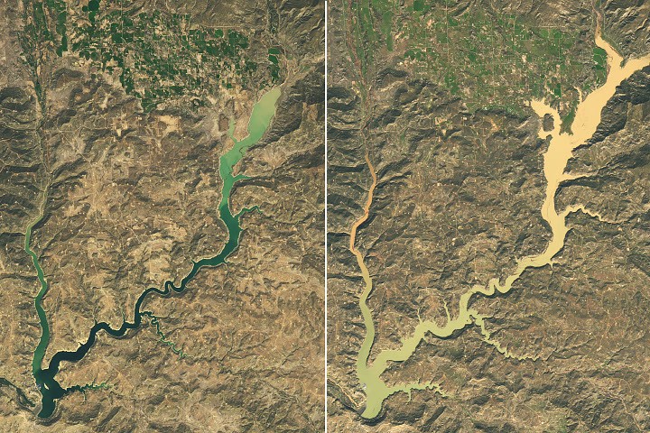
Successive rounds of heavy precipitation across the American Southwest have flooded regional river systems and driven a rapid volumetric surge into the Navajo Reservoir, according to satellite observations and earth science data released by NASA News Releases. Situated primarily in northwestern New Mexico and extending across the state line into southwestern Colorado, the reservoir—which serves as New Mexico’s second-largest body of impounded water—experienced a sharp and highly visible expansion in surface water extent after intense rainfall events swept through the upper San Juan River basin.
For regional utility planners, agricultural enterprises, and environmental monitoring agencies, the sudden hydrological influx underscores the increasing volatility of water storage dynamics across the arid Western United States. While decades of persistent drought have strained municipal water supplies and complicated interstate compact allocations throughout the broader Colorado River basin, concentrated atmospheric precipitation events remain capable of rapidly altering local reservoir baselines. Spaceborne Earth observation assets provide water resource managers with critical, real-time telemetry to evaluate watershed saturation, sediment transport, and infrastructure capacity during abrupt meteorological shifts.
Satellite Telemetry and Hydrological Context
The rapid rise in water levels at the Navajo Reservoir was documented by NASA's Earth Observatory, which utilizes orbital imaging sensors to track surface changes across critical global watersheds. Constructed as a cornerstone component of the Colorado River Storage Project, the Navajo Dam and its associated reservoir regulate the flow of the San Juan River, alongside major tributaries including the Piedra and Los Pinos rivers. When multiple waves of heavy rain stall over the surrounding mountainous terrain and high-desert plateaus, runoff converges rapidly through narrow canyon networks before entering the main reservoir basin.
Rounds of heavy rain in the U.S. Southwest flooded rivers and rapidly raised New Mexico’s second-largest reservoir.
Earth observation satellites routinely capture false-color and natural-color imagery before and after major storm systems to quantify the spatial expansion of inland water bodies. In arid and semi-arid basins where shoreline contours fluctuate significantly between dry seasons and monsoon or storm cycles, orbital imagery reveals not only the widening of reservoir channels but also the influx of suspended sediment carried downstream by swollen tributary rivers. This remote sensing data complements ground-based stream gauges by offering a comprehensive spatial overview of entire hydrological catchments.
Operational Impact on Regional Water Infrastructure
The rapid accumulation of runoff within New Mexico's second-largest reservoir carries immediate operational and economic implications for water governance across the Four Corners region. The Navajo Reservoir functions as a vital storage node for agricultural irrigation districts, municipal water systems, tribal water rights settlements, and downstream environmental flow requirements. A sudden upward shift in stored water volume alters short-term release schedules and provides temporary buffer capacity against long-term aridification trends that have challenged Southwestern utilities.
At the same time, high-velocity inflows resulting from flooded regional rivers require careful dam management and hydrological modeling. Water resource engineers rely on a combination of meteorological forecasts, upstream river gauge readings, and NASA satellite observations to balance storage recovery against flood control mandates. Heavy rainfall events over dry or sparsely vegetated terrain frequently mobilize substantial volumes of silt and organic debris, which can affect water treatment operations, alter aquatic habitats, and incrementally reduce long-term reservoir storage capacity through sedimentation.
Strategic Outlook for Spaceborne Water Monitoring
Looking ahead, the integration of satellite remote sensing into municipal and federal water management frameworks will remain essential as climate variability intensifies precipitation extremes across North America. The alternation between prolonged dry spells and intense, localized deluges places heightened pressure on legacy hydrological infrastructure designed around historical twentieth-century runoff averages. Continuous orbital monitoring enables civil authorities and commercial stakeholders to track how individual storm systems translate into net storage gains across interconnected river basins.
As water agencies in New Mexico and neighboring basin states assess their seasonal storage positions, data from NASA's Earth science fleet will continue to inform regulatory decisions, agricultural allocation models, and long-term infrastructure resilience planning. The recent surge into the Navajo Reservoir demonstrates both the responsiveness of upper-basin watersheds to concentrated rainfall and the indispensable role of space-based observation in documenting rapid environmental change across vital economic corridors.