Satellite Observations Reveal Global Rebound in Coastal Mangroves
NASA Earth Observatory analysis shows coastal mangrove ecosystems stabilizing and recovering after decades of widespread deforestation and loss.
EXECUTIVE BRIEF // KEY TAKEAWAYS
NASA Earth Observatory analysis shows coastal mangrove ecosystems stabilizing and recovering after decades of widespread deforestation and loss.
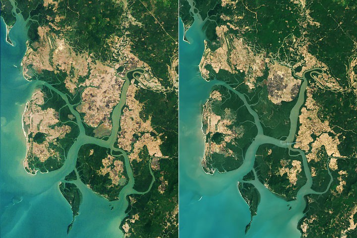
Earth observation data released in NASA News Releases indicates that global mangrove forests are staging an ecological rebound after decades of documented decline. The report, published by the NASA Earth Observatory under the headline "A Global Rebound for Mangroves," highlights a significant shift in the trajectory of one of the planet's most vital coastal ecosystems. Following prolonged periods of habitat contraction driven by coastal development and environmental pressures, remote sensing monitoring confirms that these specialized intertidal forests are beginning to recover across key global regions.
For global enterprise, environmental technology, and capital markets, the stabilization and recovery of mangrove ecosystems carry substantial implications. Mangroves serve as critical natural infrastructure, providing coastal storm surge protection that shields maritime logistics hubs, ports, and coastal real estate from extreme weather events. Furthermore, because mangrove forests are among the most dense carbon sinks on Earth, accurate satellite verification of their recovery directly impacts sovereign carbon accounting, blue carbon credit markets, and institutional environmental, social, and governance (ESG) portfolios.
Reversing Decades of Coastal Habitat Decline
Historically, mangrove ecosystems experienced severe degradation throughout the late twentieth and early twenty-first centuries. Situated at the dynamic intersection of land and sea across tropical and subtropical latitudes, these salt-tolerant trees were frequently cleared for aquaculture, agricultural expansion, timber harvesting, and industrial port infrastructure. According to the NASA Earth Observatory assessment, the narrative surrounding these ecologically significant forests was defined for decades by net loss and fragmentation.
The transition from widespread decline to a measurable rebound underscores the growing effectiveness of conservation mandates, coastal restoration initiatives, and natural regeneration processes tracked from orbit. Spaceborne instruments operated by NASA and international partner agencies allow researchers to monitor canopy density, shoreline sediment stability, and biomass changes over multi-decade timelines. By synthesizing optical and radar imagery, Earth observation platforms provide an objective baseline for evaluating how intertidal zones respond to both human intervention and shifting climatic conditions.
Technological and Economic Impact of Orbital Monitoring
The capacity to verify mangrove recovery at a global scale relies heavily on advancements in satellite remote sensing and geospatial analytics. Orbital sensors capture multispectral reflectance data across remote coastlines that are otherwise difficult and costly to survey through ground-based fieldwork alone. This technological capability enables environmental scientists, policy planners, and risk modelers to quantify changes in forest extent with high spatial and temporal resolution.
From an economic perspective, the resurgence of coastal mangrove belts strengthens resilience across vulnerable maritime corridors. Insurance underwriters and infrastructure investors increasingly incorporate natural coastal buffers into climate risk models, recognizing that intact intertidal forests attenuate wave energy and reduce erosion along industrial shorelines. Additionally, as corporate and sovereign entities seek high-integrity nature-based solutions to meet emissions targets, satellite-verified insights from institutions like the NASA Earth Observatory provide the empirical transparency required to validate blue carbon sequestration projects and prevent greenwashing in environmental asset markets.
Strategic Outlook for Earth Observation and Coastal Resilience
Looking ahead, sustaining the global rebound of mangrove forests will require continuous monitoring and coordinated coastal zone management. While the NASA Earth Observatory findings mark an encouraging milestone, intertidal ecosystems remain exposed to ongoing pressures, including accelerating sea-level rise, altered sediment supply from dammed rivers, and extreme meteorological events. Future satellite missions equipped with next-generation synthetic aperture radar and hyperspectral imaging will play a decisive role in tracking whether newly established mangrove canopies can keep pace with changing ocean levels.
For policymakers, environmental regulators, and capital allocators, the integration of public satellite telemetry into regulatory frameworks represents a critical next step. As international standards for biodiversity disclosure and natural capital accounting mature, authoritative datasets from space agencies will remain indispensable for benchmarking ecological recovery, guiding conservation capital, and safeguarding global coastal infrastructure over the coming decades.