NASA Tracks Early Sierra Snowpack Recharging Western Water Basins
NASA satellite data tracks an early mid-November snowfall across California's Sierra Nevada, providing a timely boost for regional water and power grids.
EXECUTIVE BRIEF // KEY TAKEAWAYS
NASA satellite data tracks an early mid-November snowfall across California's Sierra Nevada, providing a timely boost for regional water and power grids.
SAN FRANCISCO — A moisture-rich winter weather system swept across California in mid-November, depositing widespread early-season snow across the Sierra Nevada and delivering an essential initial deposit to the state's critical frozen reservoir, according to satellite observations released by NASA.
The snowfall marks an important operational milestone for Western commodity supply chains, municipal water authorities, and clean energy producers. California's mountain snowpack serves as a natural storage mechanism, traditionally providing roughly 30 percent of the state's total water supply as it melts during late spring and summer. For multinational agricultural operators in the Central Valley, municipal bond underwriters managing water district debts, and regional grid operators reliant on hydroelectric generation, early accumulation establishes a preliminary baseline for reservoir management and wholesale power pricing heading into the 2027 fiscal cycle.
Orbital Imaging and Hydrological Baseline
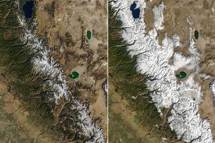
Observations recorded by the Moderate Resolution Imaging Spectroradiometer (MODIS) aboard NASA's Terra satellite captured the dramatic visual transition across the mountain range following the storm system, which made landfall around Nov. 13. High-resolution multispectral imagery revealed a sharp demarcation southeast of Lake Tahoe, where upper ridges and alpine summits were coated in fresh white cover while lower elevations and foothills retained their autumn green vegetation.
The early-season weather front brought substantial precipitation across varying elevations, dropping approximately a foot of snow across alpine crests while delivering steady, soaking rain to lower valleys, including the Sacramento metropolitan corridor. Disclosing the findings through its Earth Observatory, NASA highlighted the storm as one of the opening major precipitation episodes of the current water year, which officially commenced on Oct. 1.
According to assessment data published by the space agency's Earth Observatory desk, the timing of the storm provides a stabilizing foundation:
A widespread, early-season snowstorm blanketed California’s mountains in white in mid-November, marking an initial spin-up of the seasonal snowpack across the Sierra Nevada range.
Operational and Economic Impact on Agriculture and Energy
The arrival of measurable alpine accumulation carries significant ramifications for California's $59 billion agricultural economy and Western electricity networks. Over the past decade, severe precipitation volatility—characterized by alternating periods of historic drought and atmospheric river deluges—has disrupted capital expenditure planning for commercial growers, food processors, and public utilities. An early snowpack stabilizes soil moisture gradients before deeper winter freezes, reducing immediate groundwater overdraft across the San Joaquin Valley.
In the energy sector, early snow depth directly impacts forward risk modeling for power utilities and merchant generators. Hydroelectric facilities account for between 7 and 15 percent of California's in-state electricity generation depending on annual runoff volume, playing a vital role as flexible, zero-carbon peaking capacity to balance utility-scale solar arrays on the California Independent System Operator (CAISO) grid. The presence of solid precipitation at high elevations buffers against rapid runoff, mitigating early spillway releases and preserving reservoir head for late-spring dispatch.
Outlook: Climate Risk, Infrastructure, and Regulatory Hurdles
While mid-November precipitation provides welcome relief, water resource analysts caution that early-season snowfall does not ensure an above-average water year. Mountain snow accumulation historically peaks around April 1, leaving roughly four months of meteorological volatility that will dictate final allocations from both the State Water Project and the federal Central Valley Project. State water contractors and municipal agencies are expected to issue their initial allocation forecasts in December, incorporating satellite telemetry and ground-based sensor networks to calibrate delivery percentages.
Looking ahead, Western water administrators face compounding regulatory and structural headwinds. State regulators are continuing to implement stringent compliance requirements under the Sustainable Groundwater Management Act (SGMA), penalizing sub-basins that fail to mitigate chronic aquifer depletion. Concurrently, operators of aging conveyance infrastructure, including the California Aqueduct, face multi-billion-dollar maintenance backlogs exacerbated by past ground subsidence. The capacity of regional authorities to capitalize on early winter storms hinges on expanded groundwater recharge infrastructure, allowing excess runoff to be diverted into underground aquifers before spring snowmelt intensifies.